

This week in rocket history: the fiftieth anniversary of the launch of Landsat 1, the first satellite with the mission of observing the entire United States and the rest of Earth’s landmasses and monitoring changes over time.
In case you missed it, the Intergovernmental Panel on Climate Change released its sixth assessment report earlier this week, in which the negative impact of humans on the Earth’s climate has, unfortunately, been confirmed. The conclusions are based on many years of research and observations, using data from many sources, including satellites like the Landsat satellites operated by the USGS.
The Landsat program began with the launch of Earth Resources Technology Satellite 1 (ERTS-1), which was renamed Landsat 1 upon reaching orbit. Built and operated by NASA on behalf of the U.S. Geological Survey, it launched on July 23, 1972, on a Delta 900 from Vandenberg Air Force Base. It was the first satellite with the mission of observing the entire United States and the rest of Earth’s landmasses over time. Onboard were two instruments: the Return Beam Vidcon (RBV) and Multispectral Scanner (MSS). Both were sensitive to visible and near-infrared bands
The RBV recorded its information onto 70mm black and white film which was developed in orbit. In order to send the data back to Earth, the film was scanned with a process similar to how a television camera worked at the time. To give you an idea of size, 70mm is the same size as the film used for an IMAX movie camera.
The MSS used a 24-sensor digital detector in a whiskbroom configuration, which collected data one pixel at a time by scanning back and forth across the image swath, meaning it could only capture part of an image in a diagonal fashion as the spacecraft’s orbital motion carried it along. It scanned side to side, unlike the RBV which could capture an entire image in one exposure.
Both instruments had a ground resolution of 80 meters, so they could see things that were just a little smaller than a football field.
Unfortunately, the RBV failed before exhausting its film after taking less than 2,000 images. The MSS, on the other hand, operated until the spacecraft’s data tape recorders failed in 1978, after which the satellite was decommissioned.
However, that wasn’t the end of the program. Landsat 1 was just the first in a series of Earth observation satellites that continues to this day with Landsat 7 and 8. Landsat 2 and 3 were very similar to Landsat 1, though Landsat 3 included a thermal band in the Multispectral Scanner instrument used on the first two satellites.
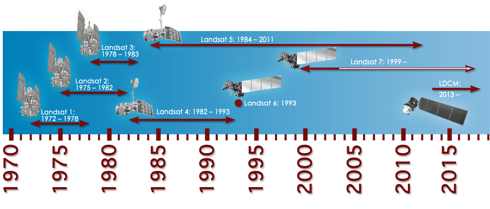
Landsat 4, which included an updated Multispectral Scanner instrument and a Thematic Mapper instrument, was operational from July 1982 to December 1993, about five years longer than expected. Its twin, Landsat 5, was launched in March 1984 and operated continuously for almost thirty years until it ceased operations in June 2013.
Landsat 6 was launched in October 1993 but failed to reach orbit. It was similar to Landsat 5 but had an upgraded panchromatic imager called the Enhanced Thematic Mapper, which had a resolution of 15 meters. That resolution is good enough to see roads. Its replacement, Landsat 7, was launched in April 1999 and is still operational to this day — 22 years and going strong. Landsat 8 was launched in February 2013 and is also still active.
Landsat 9 is currently being integrated for launch next month on an Atlas 5 rocket.
Imagery from all of the Landsat satellites is used by many different sectors, from agriculture, urban planning, forest management, and precision agriculture, to discovering new energy sources, and more. Landsat data is also used to monitor human health by monitoring mosquito breeding grounds and the health of plants using infrared measurements to identify areas affected by drought.
Landsat can help water planning by informing managers where algal blooms might form. Algal blooms are harmful concentrations of cyanobacteria that can contaminate drinking water for humans as well as kill fish and other wildlife in the water. They create toxins that cause everything from headaches to reduced neurological, kidney, and liver function. Landsat does this with its 30-meter resolution, which is capable of resolving 95% of all water sources in the U.S. It is also sensitive to the 620-nanometer wavelength that the algal blooms reflect the most.
The forty-odd-year data set is also used to monitor glaciers and ice sheets to track climate change. Landsat 8 images the entire Earth every sixteen days, allowing scientists to track the movements of glaciers in near real-time. The program is called the Global Land Ice Velocity Extraction project, or GoLIVE. When Landsat data is combined with other datasets like atmospheric and ocean conditions, scientists can figure out what causes the ice sheets to move and how the movement will affect ocean levels. This large data set spanning decades allows researchers to see changes over time and see if they’re correlated to things like anthropogenic (caused by humans) climate change.
More Information
Landsat 1 (USGS)
Landsat-1 to Landsat-3 (eoPortal)
Historic Landsat 5 Mission Ends (NASA)
VIDEO: Landsat 8 (NASA)
Landsat 9 Overview (NASA)
How Landsat Helps Us (NASA)
Landsat’s Critical Role in Protecting Human Health (NASA)
PDF: Satellites on Toxic Algae Patrol (NASA)
PDF: Landsat Provides Global View of Speed of Ice (NASA)


 Escape Velocity Space News
0 Comments