
For Rocket Roundup, we have the latest in a long series of US weather satellites, a Chinese remote sensing satellite on a small rocket’s return to flight, and another secret Chinese satellite launched into an unusual orbit. Plus, this week in rocket history we look back at the first competition flight of SpaceShipOne.
Podcast

Show Notes
Chinese smallsat lifter successfully returns to flight
- Changguang Satellite Technology press release (Chinese)
- Xinhua News Agency release (Chinese)
- Kuaizhou-1A info page (Gunter’s Space Page)
Chinese rocket launches experimental satellite
- Xinhua News Agency release (Chinese)
- TJS 2, 5, 6 info page (Gunter’s Space Page)
- TJS 1, 4 info page (Gunter’s Space Page)
- Quasi Zenith Satellite System info page (Gunter’s Space Page)
West coast Atlas V launches latest Landsat satellite
- Landsat 8 (NASA)
- Landsat 9 Overview (NASA)
- RocketStars: Avionics integration lead brings EFS to launch (ULA)
The science of geodesy
- Space Geodesy Project: Science and Applications (NASA)
- Space Geodesy Project: Laser Ranging – Satellite (SLR) and Lunar (LLR) (NASA)
- Missions Supported by Laser Ranging (NASA)
- Space Geodesy Project: What is VLBI? (NASA)
- Space Geodesy Project: What is GNSS? (NASA)
This Week in Rocket History: SpaceShipOne
- Ansari X PRIZE (X PRIZE Foundation via Internet Archive)
- Combined White Knight / SpaceShipOne Flight Tests (Scaled Composites via Internet Archive)
- SpaceShipTwo Can’t Reach 100 Km Boundary of Space (Parabolic Arc)
Transcript
Hello, and welcome to the Daily Space. My name is Annie Wilson.
And I am Beth Johnson.
Most weekdays the CosmoQuest team is here putting science in your brain.
Today, however, is for Rocket Roundup.
Let’s get to it, shall we?
This week there were three launches all on the same day, in UTC time.
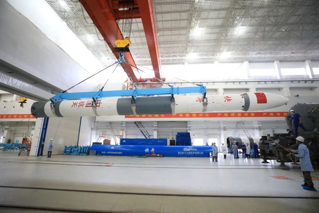
First up, on September 27 at 06:19 UTC, a Chinese Kuaizhou 1A launched Jilin-1 Gaofen 02D into sun-synchronous orbit from the Jiuquan Satellite Launch Center in China.
Jilin-1 Gaofen 02D is a commercial high-resolution optical imaging satellite capable of 75-centimeter ground resolution in panchromatic or black and white mode, with a swath width — that’s the remote sensing term for the width of an image — larger than 40 kilometers. The resolution is good enough to identify an individual car but not read its license plate. It is sensitive to visible and near-infrared wavelengths, which is useful for determining how much water is absorbed by a patch of ground.
The Kuaizhou 1A is a four-stage launch vehicle developed from the two-stage solid DF-21 road-mobile medium-range ballistic missile first deployed in 1991, with one additional solid stage and a liquid propellant fourth stage to turn it into a space launch vehicle capable of putting 400 kilograms into orbit. Like the ballistic missile it is derived from, the rocket is launched from the back of a transporter truck parked and set up on a concrete pad.
Jilin 1 02D is the next satellite in the Jilin 1 02 series. Jilin 1 02C and 02E were lost in launch failures of Kuaizhou 1A and Kuaizhou 11 rockets respectively last year. The next satellite in the series, Jilin 1 02F, will launch later this year, also on a Kuaizhou 1A.
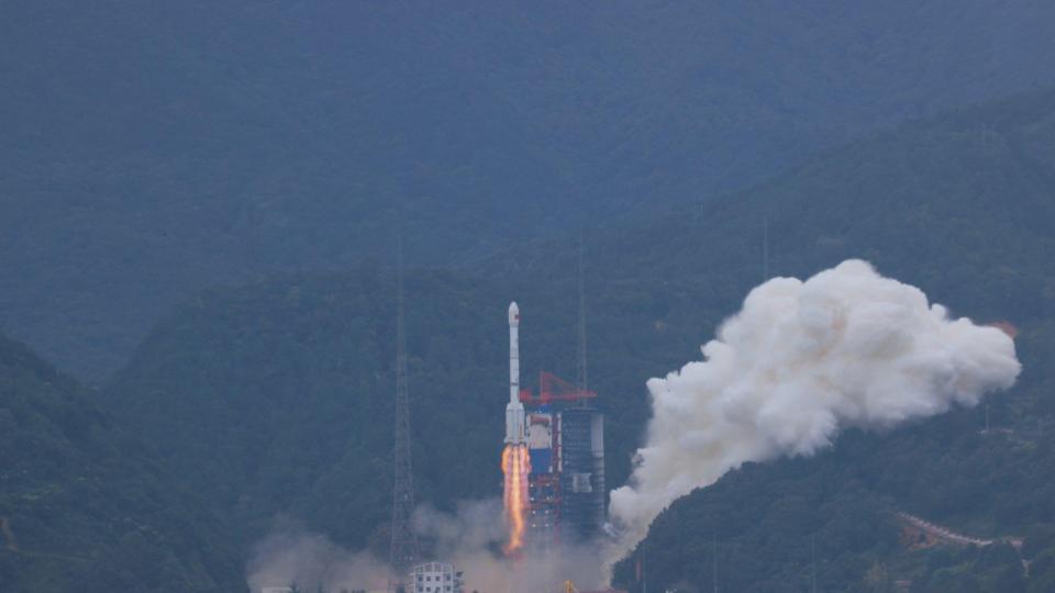
Also on September 27, at 08:20 UTC, a Chinese Long March 3B launched from the Xichang Satellite Launch Center.
Few details about this launch were released officially as of press time. We do know that the rocket launched successfully and that the satellite made it to the correct orbit. Xinhua reported that “during the rocket flight, the satellite operating conditions were abnormal, and the specific reasons are being further analyzed and investigated.”
In the press release of the launch, the spacecraft onboard was called Shiyan 10. Shiyan means “experiment” or “test” in Chinese, and this series of satellites is thought to typically have a military mission.
First a quick refresher on what geostationary and geosynchronous mean and then we’ll talk about the mysterious satellite. These are two similar-sounding terms that mean slightly different things, but the difference is important.
A geostationary orbit matches a planet’s rotation and is parallel to the equator. This means that a satellite remains fixed over one spot. Communication satellites like Direct TV use this kind of orbit.
A geosynchronous orbit matches a planet’s rotation but is not parallel to the equator. A satellite in this orbit would not remain over one spot because it is not at the equator. Japan operates a constellation of navigation satellites called QZSS, or Quasi Zenith Satellite System, in an inclined geosynchronous orbit because the country is too far north for satellites in geostationary orbit to cover it.
Shiyan 10’s orbit is unusual, at least for this series of satellites. According to tracking data from the Space Force’s 18th Space Control Squadron, it was launched into a 177-kilometer by 40,104-kilometer orbit inclined 51.06 degrees to the equator, which is an inclined geosynchronous transfer orbit. All other Shiyan series satellites have launched into a more conventional geostationary transfer orbit like a satellite launched on a Falcon 9, for example. If Shiyan 10 hadn’t failed after launch, it likely would have circularized in this 51-degree orbit and begun its mission.
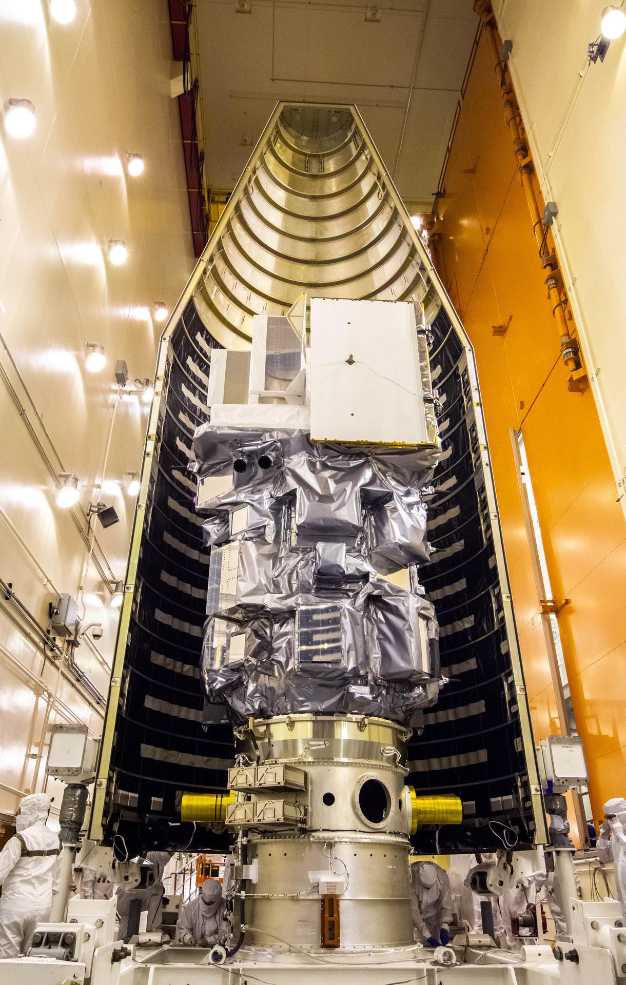
Finally, on September 27 at 18:11 UTC, a United Launch Alliance Atlas V rocket launched the Landsat 9 satellite into sun-synchronous orbit from Vandenberg Space Force Base in California.
Landsat 9 is largely the same as its predecessor, Landsat 8. Its two instruments did get upgrades and new names: Operational Land Imager 2 and Thermal Infrared Sensor 2. The Thermal Infrared Sensor 2 had more changes than Operational Land Imager 2, which will improve reliability and solve issues with stray light.
Landsat 9 launched into an orbit with a ground track eight days out of phase with Landsat 8, to improve the temporal resolution of data, which is just a fancy way of saying that those looking at the data can see changes faster when comparing two sets of images side by side.
Also on board the Centaur upper stage with Landsat 9 were four CubeSats carried in a secondary payload adapter called the ESPA Flight System, which was located below the main satellite. These include payloads for NASA, the Air Force Research Laboratory, and the Missile Defense Agency. The two NASA CubeSats are called CUTE and CuPID. According to NASA, “[Colorado Ultraviolet Transit Experiment (CUTE)] will measure how near-ultraviolet light from a host star changes when an exoplanet passes in front of it and through a planet’s atmosphere. The Cusp Plasma Imaging Detector (CuPID) from Boston University will measure X-rays emitted when solar wind plasma collides with neutral atoms in Earth’s atmosphere.”
The four CubeSats were deployed after the separation of Landsat 9 and two more burns of the Centaur to ensure the CubeSats would not interfere with Landsat 9 and also decay sooner rather than later since they have no propulsion of their own. After separating the CubeSats, the Centaur performed one final burn to deorbit itself safely into the ocean. Observers in London were treated to quite the show with the Centaurs deorbit burn and fuel dump being clearly visible from the area.
This was the first Atlas V mission to do four Centaur burns, something it has always been capable of but has not needed to do until this launch.
Since it was a pretty calm week for rocket launches, the team decided to do a deep dive into a space topic, and Erik was motivated to write about geodesy.

Geodesy is the study of the Earth’s shape, orientation in space, gravitational field, and how all of those change over time. Measurements are made with several terrestrial and space-based methods to come up with a reference frame of the Earth’s surface, from which different points on the surface can be assigned coordinates.
Traditional methods, which have their roots based on techniques developed thousands of years ago, relied on using landmarks such as the peaks of mountains, big rocks, and artificial landmarks like cairns made out of stones and brass markers. Using fairly simple tools and techniques, it’s possible to calculate distances between landmarks. If you were to combine those methods with celestial navigation techniques, you could figure out where something is.
Around the world, landmarks have been replaced by brass survey markers of various types. If you keep your eyes open, you might be able to spot one when you’re out and about.
Modern techniques build on these traditional techniques and use more precise and accurate tools to very precisely measure the location of something in three dimensions. These methods include Satellite Laser Ranging, Very Long Baseline Interferometry, and the Global Navigation Satellite System.
Satellite Laser Ranging is pretty much what it sounds like: a laser on the ground is fired at a satellite. The laser then bounces off fancy mirrors called retroreflectors on the satellite and returns to the source (the thing that fired a beam of photons into space to begin with). The time from sending to receiving the laser pulse from the spacecraft is plugged into a complicated equation that determines where the satellite is in space.
Laser-ranging on a navigation satellite is especially important because that’s one of the independent ways to determine precisely what orbit it is in, which affects the accuracy of the navigation signal. Special geodetic satellites are also launched occasionally, these are basically disco balls: solid metal balls covered in retroreflectors, designed specifically for laser ranging.
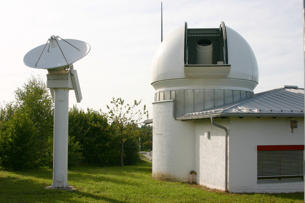
Another technique, Very Long Baseline Interferometry, uses the time difference between observations of a radio signal across many radio telescopes on Earth from a quasar, an active black hole that shoots off jets bright in radio light. These antennas have a known position to a few millimeters, so it is very easy to mark the Earth’s precise orientation in space from observation of a few quasars by several radio telescopes. The International Celestial Reference Frame is generated from this orientation.
You are probably familiar with this next technique: Global Navigation Satellite System, shortened to GNSS. In the United States, we typically just call it GPS, for Global Positioning System. GNSS uses the slight difference in timing between signals on two different frequencies sent by a navigation satellite to determine the position of the receiver. This method is less accurate because the navigation signal itself relies on laser calibration of the satellite’s orbit.
An important application of these coordinates is, of course, navigation on or just above the Earth’s surface, but the geodetic coordinates are also used to monitor how the Earth itself is moving. For example, the fact that the Earth is composed of several plates which are constantly moving, plate tectonics was a hotly debated topic in Earth sciences for most of the twentieth century. Evidence for plate movements was provided by satellite geodetic measurements and other methods. Satellite geodesy is also used to measure the sea level, necessary for all sorts of oceanographic measurements like how melting ice is affecting the sea level globally and in certain regions and cycles like the El Niño.
Beyond Earth, laser ranging is also used to track the Moon’s orbit using retroreflectors placed on the surface by Apollo missions.
This Week in Rocket History
This week in rocket history, we look back at the first competition flight of the SpaceShipOne suborbital spaceplane to win the Ansari X Prize.
The Ansari X Prize began in the late 1990s with the goal of motivating private industry to pursue human spaceflight. To win the $10 million prize, teams had to fly three people to above 100 kilometers twice in two weeks. It was inspired by the Orteig Prize for crossing the Atlantic in the 1920s, which essentially began the commercial aviation industry.
Many teams signed up to compete in the competition, including:
- Armadillo Aerospace, which later did pioneering work on small propulsive landing reusable rockets
- Interorbital Systems, who are still trying to build an orbital rocket to launch small satellites
- Scaled Composites, maker of numerous experimental aircraft including the Rocket Racer, and the Roc, the world’s largest plane by wingspan
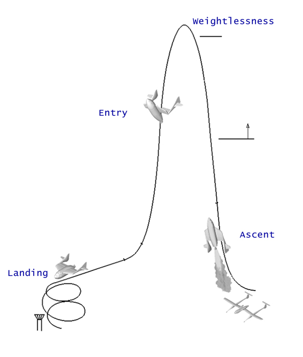
Formally called the Rutan Model 316, SpaceShip One is a two-stage rocket using a jet-powered aircraft as the first stage which carries the second stage rocket-powered space plane up to 50,000 feet where it is released. The spaceplane then fires its motor and climbs into space. To manage the forces of reentry, the spaceplane folds its wings into a high-drag “feathered” position where it is passively stable. Once through reentry, the wings are lowered again and the space plane glides to a runway landing.
SpaceShipOne did an extensive series of unpowered and powered test flights prior to attempting a spaceflight. Development started in 1999 and flight tests took place in 2003.

The first powered flight of SpaceShipOne was on December 17, 2003. It was mostly successful except for a landing gear failure, which caused some damage to the vehicle. The second powered flight was much smoother and reached an altitude of 30 kilometers with a flight time of 1 hour 16 minutes 27 seconds. The third flight reached 45 kilometers and was also well-controlled.
The fourth flight reached over 100 kilometers — the first non-governmental spacecraft to do so. However, this flight did not count as a competition flight for the X Prize because no public notice was given 60 days prior, per requirements.
The first actual competition flight took place on September 29, 2004, when SpaceShipOne was carried to an altitude of 14 kilometers and released. The only person on board was the pilot, Mike Melville. In the cabin with him were 180 kilograms of ballast representing two passengers and several personal items from the Scaled Composites team, including Burt Rutan’s slide rule, a copy of Charles Lindbergh’s book, and a teddy bear, the mascot of the Great North Air Ambulance Service. After a 77-second rocket burn and coast, the vehicle reached an apogee of 103 kilometers, above the Kármán line and in space. The descent and landing were nominal, completing the first flight of two required by the X Prize.
The ascent, however, was far from nominal.
Pilot Mike Mellvile fought a 190 degree per second roll during the engine burn. The roll was not completely under control until the spaceplane was out of the atmosphere and the reaction control thrusters could take over. The rocket motor could have burned longer, but it was shut down due to the roll when Mike knew he would get above 100 kilometers to win the prize. Post-landing analysis revealed that the roll was due to asymmetric thrust from the spaceplane’s single hybrid rocket motor, which may have been caused by improper packing of the solid propellant.
As well, the plane was traveling at Mach 2.7 at a low angle of attack because the pilot pulled up very steeply at the beginning of the burn, producing very little lift. This, combined with the speed, produced yaw instability in the plane, causing the roll. This flight profile had not been tested before. (The problem was fixed in the second competition flight by flying a flatter trajectory.) Mike inadvertently set a world record for most aileron rolls during a vertical climb.
The second flight was required to use the same space plane and fly no later than two weeks after the first flight. It did, giving Scaled Composites the $10 million prize.
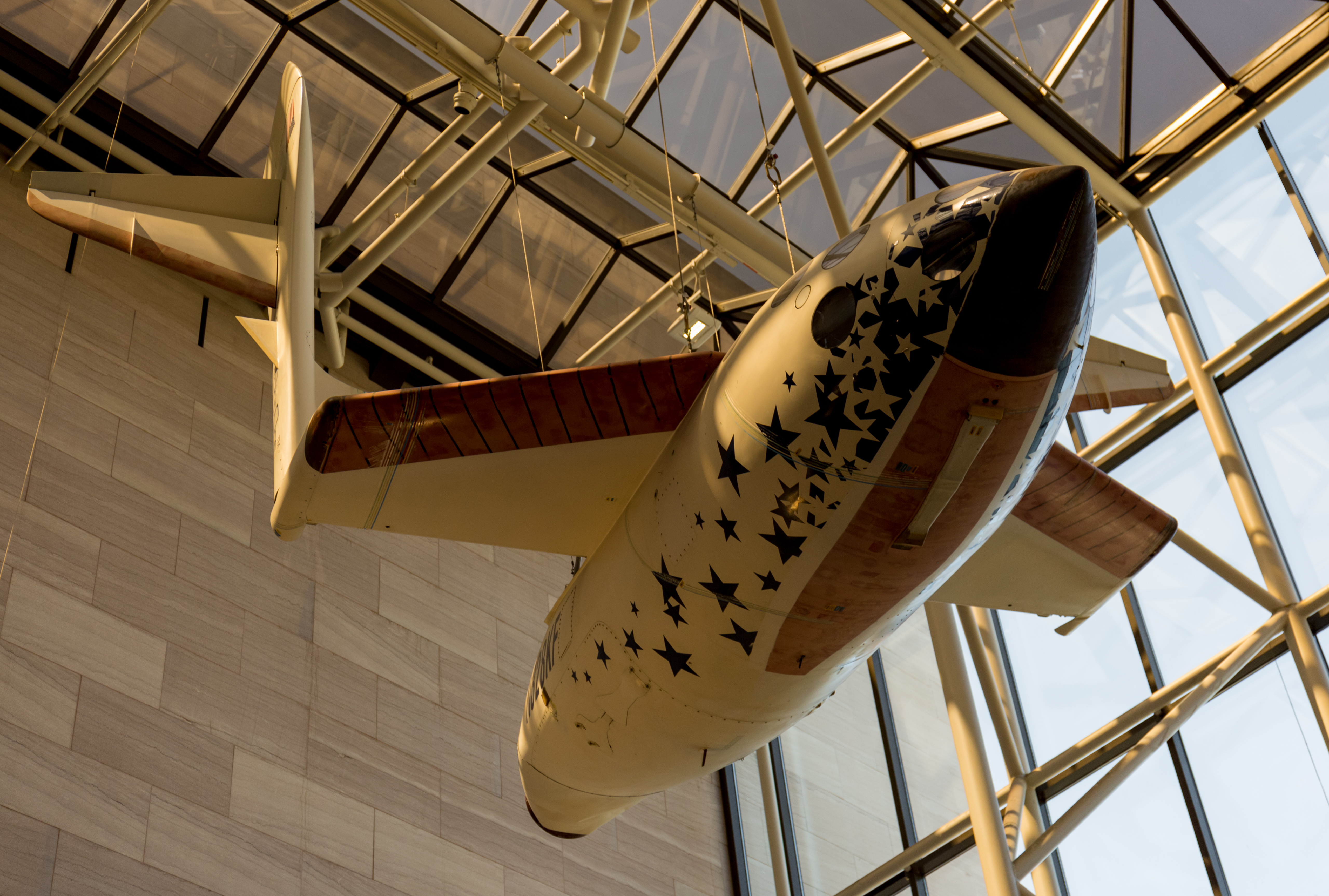
After the second competition flight SpaceShipOne was immediately retired and now hangs in the atrium of the National Air and Space Museum in Washington, DC.
Seventeen years later, its successor, SpaceShipTwo, has yet to begin regular commercial flights. It is also incapable of reaching the 100-kilometer Kármán line, unlike SpaceShipOne, because it carries six passengers instead of two using the same performance motor.
Statistics
To wrap things up, here’s a running tally of a few spaceflight statistics for the current year:
Toilets currently in space: 7: 4 installed on ISS, 1 on the Crew Dragon, 1 on the Soyuz, and 1 on Tianhe.
Total 2021 orbital launch attempts: 95, including 8 failures
Total satellites from launches: 1461
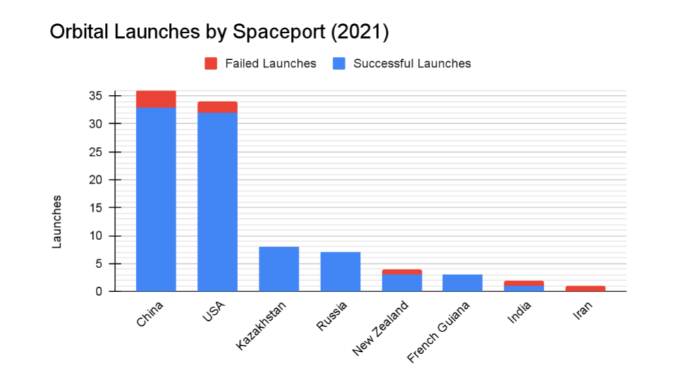
I keep track of orbital launches by where they launched from, also known as spaceport. Here’s that breakdown:
China: 36
USA: 34
Kazakhstan: 8
Russia: 7
New Zealand: 4
French Guinea: 3
India: 2
Iran: 1
Your random space fact is that the New Horizons spacecraft carries a fragment of the fuselage of the SpaceShipOne suborbital spaceplane.
This has been the Daily Space.
You can find more information on all our stories, including images, at DailySpace.org. As always, we’re here thanks to the donations of people like you. If you like our content, please consider joining our Patreon at Patreon.com/CosmoQuestX.
Credits
Hosts: Annie Wilson and Beth Johnson
Writers: Gordon Dewis, Pamela Gay, Erik Madaus, and Annie Wilson
Audio and Video Editing: Ally Pelphrey
Content Editing: Beth Johnson
Executive Producer: Pamela Gay
Intro and Outro music by Kevin MacLeod, https://incompetech.com/music/
 We record most shows live, on Twitch. Follow us today to get alerts when we go live.