
The discovery of multicellular algae specimens in an early Cambrian formation in China provides evidence of the change from cyanobacteria to more complex organisms with external membranes and cell walls. Plus, a new spacesuit is tested in Oregon, and we look at the real secrets of Stonehenge.
Podcast

Transcript
Hello and welcome to the Daily Space. I am your host Dr. Pamela Gay.
And I am your host Beth Johnson.
And we are here to put science in your brain.
Over the course of our planet’s history, glaciers have come and gone. At one point, glaciers extended across all of what is modern-day Canada and down into much of the present-day United States. We see traces of these glaciers in the distributions of rocks and boulders on the landscapes and in the twisted terrain they left behind.
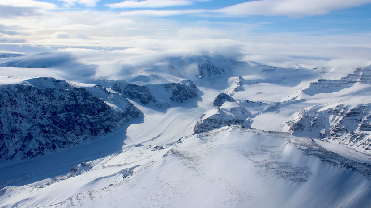
While being able to see glacial structures isn’t new, the diversity we’re able to see today is expanding as new glaciers melt and reveal the ground beneath. This is one of the weird opportunities we get thanks to climate change, and the structures being revealed are discussed in a new article in Reviews of Geophysics that summarizes 200 years of structural glaciological investigations. This article was written by Stephen Jennings and Michael Hambrey.
Glacial melting is revealing landscapes never before seen that capture the history of our planet. In Alpine valleys, researchers can now see the scars of the “Little Ice Age” that spanned from the 1300s to about 1850. In Svalbard, the terrain looks like corrugated cardboard from how the layered glacial structures have melted away. Greenland, in particular, is covered in ice sheets and glaciers, and its melting will be one of the largest contributors to global sea-level rise; already Greenland’s melting has revealed landscapes likely never seen by human eyes.
And in studying the ice that is still there in Greenland, researchers have discovered one small thing to celebrate: it turns out that our warming world may trigger weather patterns that are capable of dumping more snow onto Greenland’s mountains – snow that can start to build new glaciers. New research, led by Matthew Osman and appearing in Nature Geoscience, describes how historically, it has snowed more on Greenland’s peaks during warmer weather – weather that is warmer but not too much warmer – than it has during extreme cold.
Anyone who grew up in a snowy region knows that it can be too cold to snow and that the nastiest snowstorms occur when it is only a few degrees below zero. This past week, a massive amount of snow was dumped on Greenland by Hurricane Larry, and there is hope that such climate-change-driven storms of the future may allow new glaciers to begin to grow at high altitudes. This won’t save our world from climate change, but it does offer some small hope that there will still be glaciers to study in the future.
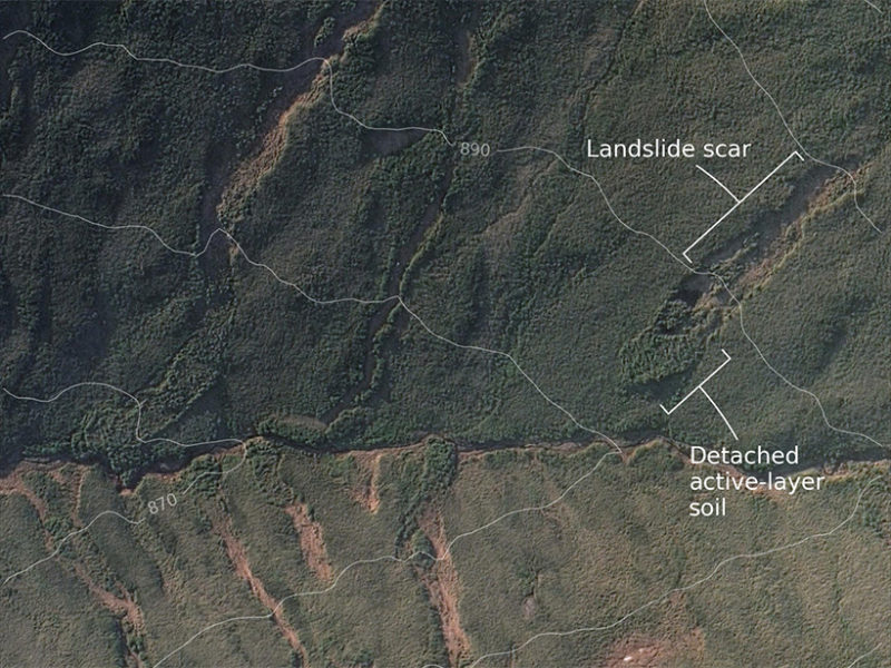
Glaciers aren’t the only thing sliding down mountains thanks to melting. In the extreme northern and southern latitudes of our world, there are regions where, until recently, the earth – and here I mean the soil – was constantly below freezing. While the top bit of land might melt enough to allow grasses and some trees to grow, any significant amount of digging would be brought to a halt by ice. That ice is melting, and it turns out that melting ice in soil and melting frosting on a cake can both cause things to slide and crumple.
Another new paper, this time in Geophysical Research Letters and led by H.T. Mithan, is showing that ice lenses – places where ice is focused beneath the landscape – can melt and inject significant amounts of water into the soil, causing a landslide in which the top part of a hill or mountain simply slides down, leaving behind an empty scar.
In a study of a 100-square-kilometer region of Alaska, this paper’s authors were able to identify 188 events in satellite images from a single year. While most occurred far from humans, there is the potential for these kinds of events to destroy communities, and this research is now being used to try and identify where ice lenses are likely lurking beneath the landscape. By identifying the dangerous ice before it melts, it may become possible to put in warning systems or otherwise mitigate potential damage and loss of life.
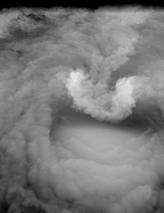
The role of ice and water on our planet and in our atmosphere is something that we haven’t always paid enough attention to. For instance, in trying to identify where tornadoes will form, researchers are only just beginning to model how water moves through the atmosphere.
In a new paper in Science, researchers led by Morgan O’Neill model how storms capable of generating tornadoes go beyond the usual anvil cloud structure of thunderstorms and form an above-anvil cirrus plume of ice and water vapor.
According to the computer models, this plume can transport seven tonnes of water per second into the stratosphere! These plumes form thirty minutes or more prior to severe weather striking at ground level. While not readily observed, these plumes offer a potential method to identify where the worst weather associated with hurricanes and other massive storms may occur.
This work is still in its early stages, but according to O’Neill: High-altitude NASA research aircraft have only recently gained the ability to observe the three-dimensional winds at the tops of thunderstorms… We have the technology now to go verify our modeling results and see if they’re realistic. That’s really a sweet spot for science.
Despite the looming threat of climate change, this year continues on its inexorable march toward 2022, which is almost unbelievable to me since I swear it’s still 2020.
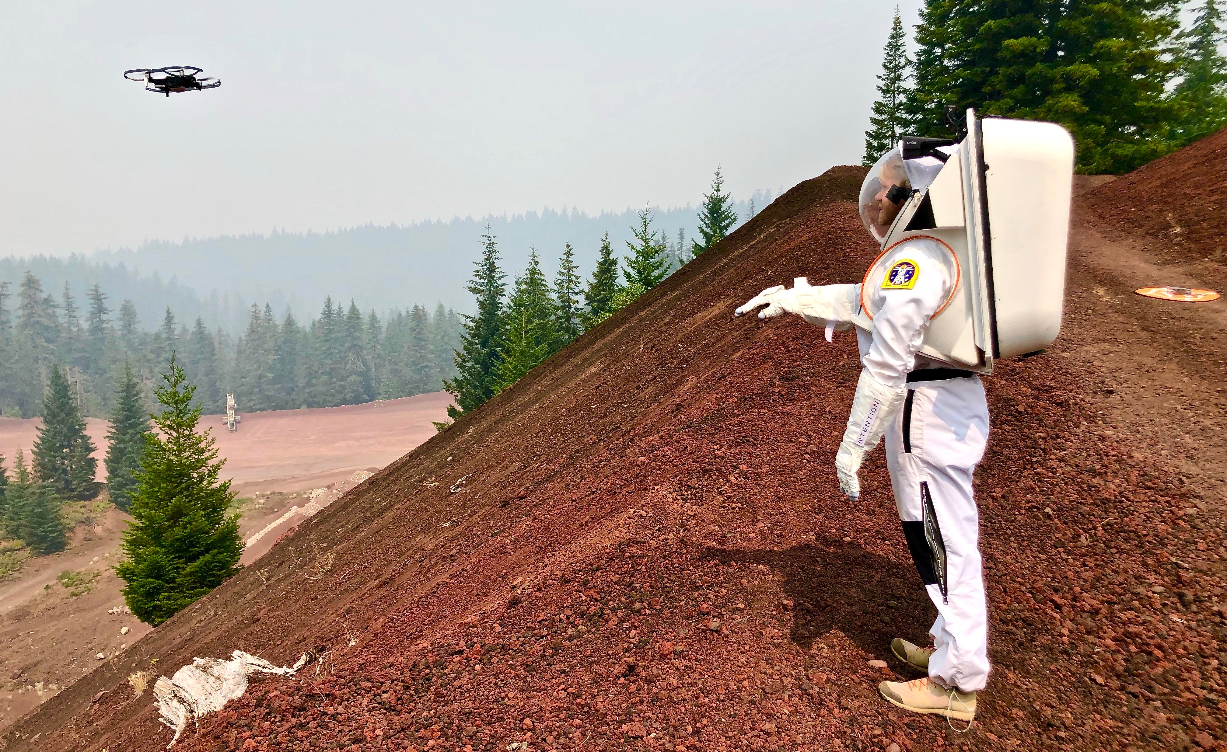
We also continue to make progress toward that somewhat nebulous date when NASA will launch the Artemis mission. That mission’s goal is to land the first woman and the next man on the Moon, with a landing site near the lunar south pole where accessible water ice is most likely to be found. And while we have focused mainly on the transportation to get back to the Moon, rockets and vehicles are not the only concern. Our next story takes a look at another important aspect of the mission – spacesuits.
After all, the latest SpaceX suits are cool and all, but they’re not good for wandering the surface of the Moon.
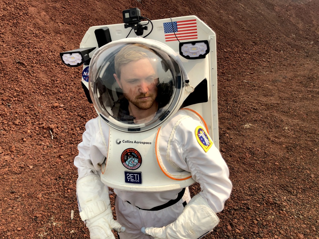
To that end, NASA’s Haughton-Mars Project in conjunction with the SETI Institute, Mars Institute, Collins Aerospace, and Ntention have been field testing some new spacesuit technologies in Oregon’s High Desert region. Some of these sites are the same sites once used by Apollo astronauts to test their own spacesuit technology and train in its usage back in the Apollo era. SETI’s Dr. Pascal Lee notes: It was exciting to be in Oregon to revisit some of the very locations where, in 1964 and 1966, the Apollo astronauts received field training in geology and tested spacesuits.
The list of testing sites included the legacy sites of Lava Butte, Big Obsidian Lava Flow, Fort Rock, Hole in the Ground, and Yapoah Lava Flow at McKenzie Pass.
Plus, the team found some more analog sites for further testing and exploration, now that we know more about the surfaces of the Moon and even Mars than we did decades ago. Those sites included Pumice Slope at Crater Lake National Park, the Painted Hills at John Day Fossil Beds National Monument, and Skylight Cave. Interestingly, that last site is a lava tube with several openings in the roof from collapses, which is great for testing a lunar lava tube analog.
The testing had the support of the United States Forest Service and National Park Service.
Now let’s talk about these new spacesuits. One of the new innovations is an integrated Information Technologies and Informatics Subsystem or IT IS designed by Collins Aerospace. The IT IS is basically a heads-up display in the spacesuit helmet that allows astronauts to track various checklists and replaces the low-tech spiral-bound notebooks that they had attached to their elbows. Additionally, the IT IS allows them to track their health and that of their fellow astronauts as well as check the status of various spacesuit systems, including power, oxygen, and water reserves. The display will also show maps and locations and allow for note-taking, sample management, and even some photography.
Talk about an all-in-one package.
It’s important that we make these advances, and as Dr. Lee goes on to explain: While real-time mission support from Earth will remain important, exploring the lunar poles, where NASA intends to land Artemis astronauts, means that direct-to-earth communications will not, at times, be possible, even via orbital relays. So we need to provide future lunar explorers with the means to safely perform more autonomous EVAs. The need for autonomy will be further compounded in the case of Mars, where communications delays will drastically limit real-time mission support from Earth.
One more new technology was tested out in Oregon – Ntention’s Astronaut Smart Glove, which had been previously tested in the field before but this time was successfully integrated with the new IT IS.
The glove allows astronauts to remotely operate robotic assistants like cranes, rovers, and drones via minimal hand gestures. That’s important because spacesuits, especially those used on the Moon, are not known for their flexibility or maneuverability. And the field test for this glove gave a demonstration of a successful rock sample collection using that remote technology. Given that the lunar south pole may not be the easiest for people to get around, the ability to use a rover and direct it from the field, so to speak, is a huge stride in making the Artemis mission successful.
We’ll link to more amazing images of the new spacesuit in action in our show notes at DailySpace.org.
One of the reasons Beth loves geology is because you can go from studying the Moon and Mars as a planetary scientist to studying fossils here on Earth, and it’s all under the same scientific umbrella. Now, I’m not going to say I have some grand love for fossils and such unless they are dinosaurs, but I do share Beth’s fascination for understanding the evolution of life.
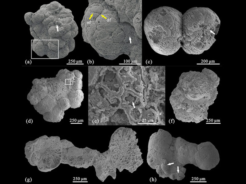
In new work published in the Journal of Geophysical Research: Biogeosciences, scientists have managed to characterize the discovery of fossilized algae found in China. The formation where these algae were located dates back to the Cambrian period, about 500 million years ago. That’s interesting in and of itself, but the most interesting part is that the algae have external membranes and cell walls.
Let’s back up just a little. Back in the very before times, some of the first critters here on Earth were cyanobacteria. While these are also known as “blue-green algae”, they are not, in fact, algae. They are similar to algae: both use photosynthesis to obtain energy from sunlight. In fact, cyanobacteria are one of the big reasons we have so much oxygen and made it possible for life as we know it to exist.
But cyanobacteria are relatively simple compared to algae, and the rise of algae accelerated the development of life by creating a more efficient food web. Nutrient transfer between species became easier, allowing for more species to arise.
These recently discovered fossils take the cyanobacteria and early algae another step further. Using scanning electron microscopy and X-ray tomography, scientists found that the fossilized organisms were organized into large spatial patterns — an inner cortex and outer medulla. They look to me like little tiny brains.
And this structure suggests that the organisms were asexual, growing from a round ball of cells into the more complicated collection. Each “brain” lobe contains its own organization of cortex and medulla, too. These new specimens are consistent with more contemporary specimens found in China, which gives us a new timeline for their development.
We’re always on a quest for understanding life in the universe, and with this sample planet of exactly one, we will dig through rocks to find as many specimens throughout time as we possibly can.
Stonehenge is one of the great archaeological wonders of the world, and one of the most misunderstood places we all think we know about. First off, while all the photos we generally see depict it as this pristine place that embodies the magical feeling of fairy stories, the reality is that it is located next to a busy highway, and the land still shows the scars of prior roadways. Further, it is surrounded by a low-key fence that keeps out sheep.
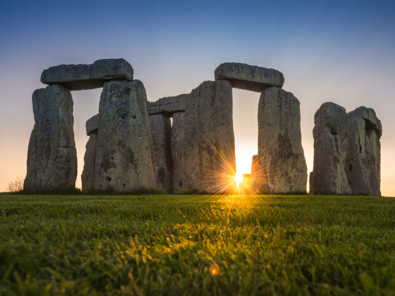
When I visited about ten years ago, I was struck by the feeling that Stonehenge is just a weird rock formation in the midst of a farmer’s sheep pasture, and that whoever designed the British highway system had no love for either farms or archaeology.
Originally built with an estimated eighty massive Sarsen stones, the structure we see today is just part of a long utilized site that has previously featured additional pits, poles, and stones whose uses aren’t entirely understood but in many cases are consistent with tracking the passage of the Sun, Moon, and seasons.
While the use of the site is a curiosity we may never fully understand, many researchers are even more mystified by the stones – how they got there and how they were leveraged into place in a time prior to cranes and hydraulic lifts. Again, many different theories abound, many of which include rolling the stones along on a conveyor belt of rounded logs and using a lot of temporary earthen berms and ramps, just like a Minecraft player using dirt instead of scaffolding.
Growing up, I was often told that these Sarsen Stones were quarried from one of several potential sites several kilometers away. As a kid growing up in a town with a granite quarry, I imagined that this meant chipping away to cut massive stones out of a larger area of stone and then transporting them, but this idea was also wrong.
Sarsen stones are actually large sandstone blocks left during a post-glacial period and scattered throughout the landscape of Salisbury Plain, Marlborough Downs, and other areas. While they came in beds that required digging out the stones, they were already, more or less, the giant blocks that we see today.
I say more or less because of new research coming out in PLOS One and led by David Nash. The team was able to study both the actual Sarsen stones using X-ray spectroscopy. This is a non-destructive process where they literally just shine X-rays into the rock and study how it shines back. Unfortunately, this method only lets researchers see a little way into the rock, but a chance phone call allowed the researchers to see all the way through the stones.
It turns out that stone 58 toppled in 1797, and when it was stood back up in 1958, three core samples were removed while metal rods were inserted. Only one of these three is accessible. That sample is in the private hands of collector Robert Phillips – a worker from the restoration project – who allowed Nash and his team to study the stone all the way through. And it turns out, they are quartz all the way through.
Originally, the stones were likely collected in Wiltshire Woods where they appeared as giant blocks with layers of weathered, cemented stone on their surface, but those layers could be polished away, and when first erected, the stones of Stonehenge were dressed to appear as glorious white quartz. Time, weather, and lichen have dulled them to today’s grey, but once upon a time, the legendary site shone in the sunlight.
And now you know! The rocks were dug up as blocks, transported, cleaned to a shining glory, and then surrounded by a highway… and sheep.
This has been the Daily Space.
You can find more information on all our stories, including images, at DailySpace.org. As always, we’re here thanks to the donations of people like you. If you like our content, please consider joining our Patreon at Patreon.com/CosmoQuestX.
Learn More
Melting Glaciers Reveal New Landscapes
- Glacier Structures: History Written in the Ice (Eos)
- “Structures and Deformation in Glaciers and Ice Sheets,” Stephen J. A. Jennings and Michael J. Hambrey, 2021 July 27, Review of Geophysics
- Woods Hole press release
- “Abrupt Common Era hydroclimate shifts drive west Greenland ice cap change,” Matthew B. Osman et al., 2021 September 9, Nature Geoscience
And Melting Ice Lenses Cause Landslides
- Ice Lenses May Cause Many Arctic Landslides (Eos)
- “Topographic and Ground-Ice Controls on Shallow Landsliding in Thawing Arctic Permafrost,” H. T. Mithan, T. C. Hales, and P. J. Cleall, 2021 June 26, Geophysical Research Letters
Icy Plumes Transport Water Into Stratosphere
- Stanford press release
- “Hydraulic jump dynamics above supercell thunderstorms,” Morgan E O’Neill, Leigh Orf, Gerald M. Heymsfield, and Kelton Halbert, 2021 September 10, Science
New Spacesuits Tested in Oregon at Apollo Training Sites
- SETI Institute press release
Early Cambrian Formation Hides Multicellular Algae Fossils
- Multicellular Algae Discovered in an Early Cambrian Formation (Eos)
- “Characterization of the Multicellular Membrane-Bearing Algae From the Kuanchuanpu Biota (Cambrian: Terreneuvian),” Yajuan Zheng et al., 2021 June 7, JGR Biogeosciences
Stonehenge Sarsen Stones Made Entirely of Quartz
- State-of-the-Art Technology, Serendipity, and Secrets of Stonehenge (Eos)
- “Petrological and geochemical characterisation of the sarsen stones at Stonehenge,” David J. Nash et al., 2021 August 4, PLOS One
Credits
Written by Pamela Gay and Beth Johnson
Hosted by Pamela Gay and Beth Johnson
Audio and Video Editing by Ally Pelphrey
Content Editing by Beth Johnson
Intro and Outro music by Kevin MacLeod, https://incompetech.com/music/
 We record most shows live, on Twitch. Follow us today to get alerts when we go live.