
The Hunga Tonga-Hunga Ha’apai volcano in the Kingdom of Tonga erupted on January 15, and despite communications being cut off, government officials and scientists have gathered a wealth of information about the event and its outcome so far. Plus, urban heat islands, volcanic lightning, and What’s Up.
Podcast

Show Notes
Cities cool under COVID-19
- “Urban Heat Islands Significantly Reduced by COVID-19 Lockdown,” Zihan Liu et al., 2022 January 11, Geophysical Research Letters
Volcanoes trigger massive thunderstorms
- GSA press release
- “Eruption dynamics leading to a volcanic thunderstorm—The January 2020 eruption of Taal volcano, Philippines,” Alexa R. Van Eaton, Cassandra M. Smith, Michael Pavolonis, and Ryan Said, 2022 January 18, Geology
In-Depth: Hunga Tonga-Hunga Ha’apai eruption
- Tonga volcano: New images reveal scale of damage after tsunami (BBC News)
- Tonga volcano felt around the world (EarthSky)
- The Tonga eruption explained, from tsunami warnings to sonic booms (National Geographic)
- Report on Hunga Tonga-Hunga Ha’apai (Tonga) — 12 January-18 January 2022 (Smithsonian Institution)
- Expanding Islands In The South Pacific (Planet Labs)
- Hunga Tonga-Hunga Ha‘apai Erupts (NASA Earth Observatory)
What’s Up: Asteroid 1994 PC1 is visible in binoculars
- 7482 (1994 PC1) (JPL Small-Body Database)
- 7482 1994 PC1 (Asteroid) (In-the-Sky)
Transcript
Hello and welcome to the Daily Space. I am your host Dr. Pamela Gay.
And I am your host Beth Johnson.
And we are here to put science in your brain.
And given an entire universe of objects to produce science, somehow today’s headlines are all related to our one not-entirely-calm world, Earth, and the humans that find ways to change its surface and atmosphere.
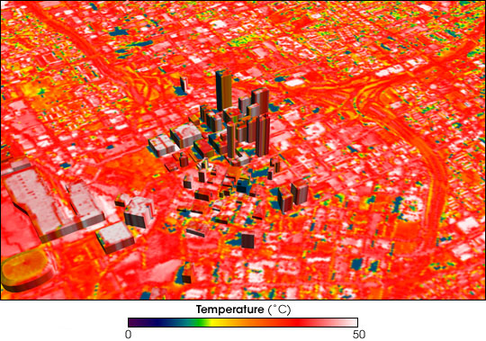
During the past two years of this pandemic, we’ve seen a lot of human suffering, but we’ve also seen the skies over some of the world’s cities clear as cars have stayed parked and factories have slowed or stopped production. Here in small town America, we’ve seen wildlife come into town, with coyotes now hunting neighborhood cats instead of farm chickens. These changes are stark reminders of our effects on the world, but the effects we see with our eyes don’t help us understand if these change local or global temperatures and the weather they moderate.
Understanding that requires satellites and ground stations.
In a new paper in Geophysical Research Letters, researchers led by Zihan Liu, look at data for 300 massive cities in China – cities that sprawl over more than ten square kilometers and include many megacities of more than ten million people.
It was known that cities act as urban heat islands, with human activities and infrastructure raising the temperatures above those of the less developed surroundings. This is especially true in high latitudes during the winter, where heated buildings also heat their surroundings. A/C also pumps inside heat into the environment. Added greenhouse gases from vehicles contribute as well.
During the pandemic lockdowns, however, when fewer vehicles were used and many buildings and public transportation systems were shut down, cooling of a quarter degree Celsius was measured at ground level and closer to half a degree in the atmospheric canopy over the cities.
While fractions of a degree may not seem a lot, these are the kinds of changes that make all the difference in the world with climate change, and this points to how just working from home may be an answer for making a better future.
Solving our current climate crisis is going to take more than changing how we work. Exactly what it will take… With the eruption of a massive volcano in Tonga this weekend, it was hoped maybe the Earth was going to help us out with some good old-fashioned, high-level ash to drop the temperatures. Beth and Erik have spent the week putting together in-depth coverage of that volcano, which we will get to in the next two segments, but right now, I can tell you that volcano was not the ash monster we need.
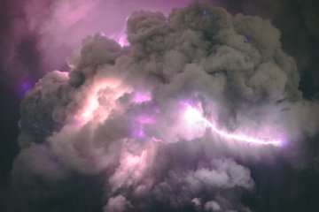
The ash in volcanoes is a vile substance that is sharp, readily builds up static, and generates lightning. This lightning, in turn, can be observed by satellites, allowing us to pinpoint active eruptions even in areas of cloud cover and in some cases, understand the evolution of an ash plume based on lightning activity.
As a case study, researchers examined data from the 2020 Taal Volcano eruption in the Philippines. Erupting near a city, this volcano was monitored by both satellites and social media posts from people all around it. In a new paper in the journal Geology, researchers led by Alexa Van Eaton were able to study the eruption in depth using lightning data. According to Van Eaton: The eruption took place in a major urban area, so people posted pictures of volcanic lightning as it was happening.
And those posts “reveal a highly electrified region at the base of the umbrella cloud.”
Social media is, over and over, allowing researchers to recreate both natural and human-made events. Van Eaton goes on to say: Much more can be done to characterize an eruption when there are camera perspectives from all angles. And understanding the evolution of volcanic lightning helps us recognize the early warning signs of ash hazards to aircraft.
One of the reasons I wanted to cover this story is because, on Sunday, a misunderstood ash report led France’s AFP news agency to put out an alert that the Tonga volcano had a second major eruption. This was misreported in a growing game of telephone by myriad news agencies, and it was the lack of lightning strikes that allowed volcanologist Dr. Janine Krippner to assure me and others on Twitter that those stories were just wrong. So where there’s smoke, there is fire, and where there is a volcanic eruption, there is lightning. When in doubt, look for the electric strikes.
In-Depth
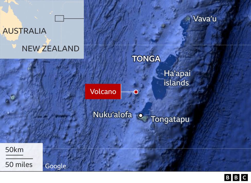
Earlier this week, we talked briefly about the volcanic eruptions occurring in the Kingdom of Tonga last weekend, and we promised you an in-depth look at the situation. Scientists are continuing to analyze a wealth of data, with more coming in every day, but here is what we know so far.
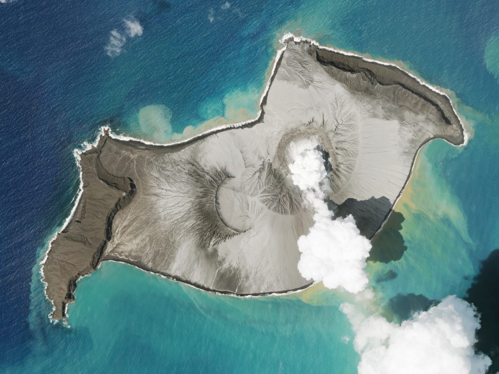
Several weeks ago, on December 20, 2021, the submarine volcano Hunga Tonga-Hunga Ha’apai began to erupt. That initial set of eruptions was barely noted in international media, with most of the coverage remaining local because nothing much was going on. The visible portion of the volcano, or rather, the island produced at the surface, grew based on an analysis of satellite images. But the volcano quieted back down, and by January 11, 2022, it had been declared dormant.
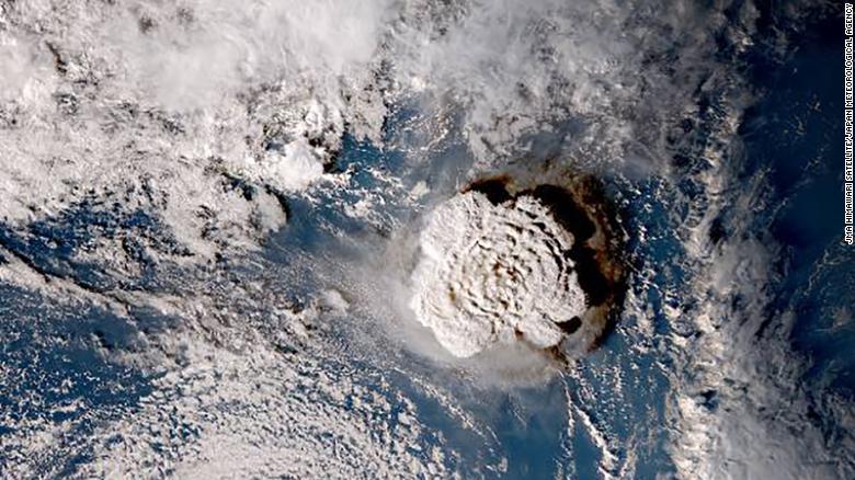
And then, at 0420 UTC on Friday, January 14 (5:20 pm local time on Saturday, January 15), a much larger eruption occurred that sent a mushroom cloud of ash, steam, and gas up into the atmosphere to a height of nearly twenty kilometers, although later analysis of sulfur dioxide plumes in the stratosphere suggests the height was closer to thirty kilometers. Geologists observing from an ocean vessel nearby noted that the base of the mushroom cloud was about five kilometers wide.
Incredibly, initial reports on Twitter had people hearing the explosion as far away as Australia, Samoa, and Fiji, but further analysis in the past few days has led to the discovery that the explosion was heard as far away as Anchorage, Alaska. I personally checked in with a colleague to ascertain if the very loud boom we heard here at my house on Friday night could have been the eruption as well, and she confirmed that yes, it absolutely could be and probably was.
Ashfall from the eruption coated the Tongan islands, and a tsunami warning was issued for both the Kingdom of Tonga and much of the Pacific Ocean. The initial wave height was about twenty centimeters, which may not sound like much, but later waves were almost two meters high. From images released earlier this week by the Tongan government, several villages were wiped out, numerous other buildings were damaged or destroyed, and there was a lot of minor damage nearly everywhere on every island.
Additionally, the nation was cut off from the rest of the world due to an underwater cable being severed during the massive eruption, which made coordinating rescue and relief efforts difficult and also challenged the government in its ability to assess all the damage. Hence why the assessment was only released a couple of days ago. Plus, with all the ashfall, the airports in the nation were closed because runway markings were not visible. Communications between islands were limited to patrol boats.
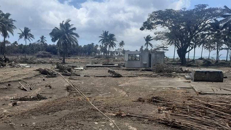
At least three people in Tonga were killed due to the tsunami, with more injured and missing, although due to the tsunami warning, those numbers seem to have been kept very low.
Damage was not limited to Tonga, however. The tsunami rolled through the Pacific Ocean, where waves reached Japan that were eighty centimeters in height and caused damage to harbors and boats. Similar effects were seen along the coast of North America, with waves between twenty and 100 centimeters in Alaska, and about 25 centimeters in British Columbia. Harbors in California also saw increased wave activity and harbor damage. In Peru, two people were killed as a result of the tsunami, and news sources there also reported flooding and damage.
One of the more fascinating side effects of this eruption is the huge amount of electrical activity in the ash cloud itself, which generated hundreds of thousands of lightning discharges. Remember from earlier in the show that volcanoes can produce lightning, and this volcano produced more of it than any eruption recorded to date. The lightning strikes were detected by Vaisala’s GLD360 network, which basically “hears” lightning as radio waves. There was a point during the major eruption when the ash cloud produced over 200,000 discharges in one hour.
And the GLD360 network wasn’t the only system keeping an eye on this volcano and revealing a wealth of information.
In the weeks leading up to the eruptions of the Hunga Tonga-Hunga Ha’apai volcano in Tonga, a fleet of spacecraft from governments and countries were monitoring it from space. These included the commercial satellites from Planet Labs and the Sentinel constellation run by the European Space Agency. Still other spacecraft observed the volcano from high orbit, including NASA’s GOES-17 spacecraft.
Planet Labs runs a constellation called PlanetScope with two different types of spacecraft. The smallest and most numerous are the Doves, CubeSats with a small telescope. Planet Labs also uses larger satellites called Skysat. These satellites are bigger, about 100 kilograms, and capable of taking pictures with a ground resolution of fifty centimeters. They can also take stereo images, showing an object in three dimensions. Many of the images of the volcano during its early eruptions were taken by Planet Lab’s Skysats.
Another satellite that took images of the volcano in Tonga was ESA’s Sentinel 2 optical imaging satellite, providing images of the remains of the island after the ash cloud had cleared. It has a much lower resolution than Skysat, at only ten meters per pixel.
The GOES-17 spacecraft run by NOAA is in geostationary orbit and covers the western half of the United States and the Pacific Ocean. Gifs on social media from GOES-17 data showed the 15 kilometers tall and 300 kilometers in diameter ash cloud, and more interestingly, the shockwave, spread from the island and around the world.
In between the major eruption and the ash cloud dissipating to show the aftermath, the optical satellites were unable to take any images. So, radar satellites stepped in. Radar satellites can see through ash and cloud cover. ESA’s Sentinel 1 satellite took pictures showing the first signs of the devastation before optical satellites could get images again.
The eruption of Hunga Tonga-Hunga Ha’apai is considered to be the largest eruption of this century, although I think that doesn’t take much since we’re only 20ish years in, but it’s also the largest eruption since the 1991 eruption of Mt. Pinatubo in the Philippines. That eruption caused a slight drop in global temperatures for a few years. And while we could use a global temperature drop right now, we would prefer it not be at the expense of people’s lives and their communities.
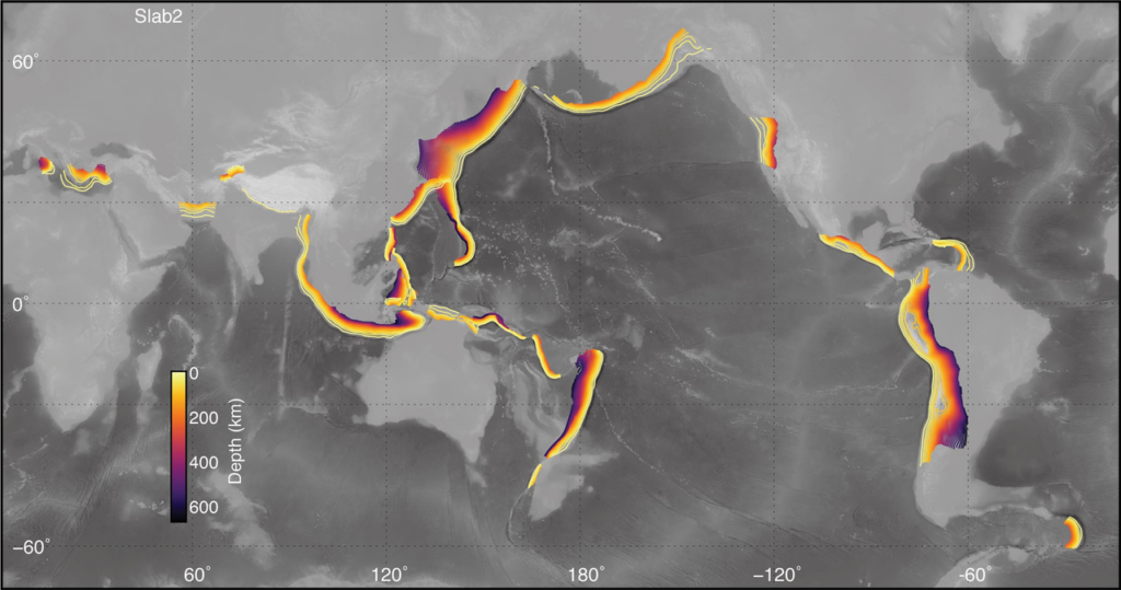
So why was this eruption so big? To understand that, you have to look at the structure of the Earth’s crust. The Pacific Ocean is surrounded by what is known as the Ring of Fire, with numerous volcanoes erupting at any given point in time. In the case of Tonga, the Pacific tectonic plate is subducting or diving down under the Australian plate. As the descending plate moves into the mantle, the rocks are heated and begin to melt. The water from the ocean gets added to the mix, which actually lowers the melting point. But these rocks don’t melt all the way into that nice, liquid magma we see from Hawaiian-type eruptions. No, this stuff is sticky, thick, and viscous; more like peanut butter than honey. So when it tries to rise up through the surrounding cooler rocks, crystals continue to grow, the water has evaporated into gas, and everything has been set up for a very explosive eruption.
Hunga Tonga-Hunga Ha’apai itself is more than nineteen kilometers wide at its base. It’s huge. And there’s a massive caldera in there that’s about five kilometers across. The volcano has been erupting since at least as far back as 1912, and during eruptions in 2014 and 2015, the island that had been appearing and disappearing for years became stable. It even had plants and some animals on it. Once things quiet down again, more plants and animals will find their way to the island.
And in one final piece of good news, aid planes and ships finally began to arrive from New Zealand and Australia just yesterday, January 19. Phone lines have also been partially restored, so information is beginning to flow from the islands again. We hope the death toll continues to remain very low and that Tonga gets the help it needs to rebuild.
What’s Up
This week in What’s Up is an asteroid, one that you can actually see in a backyard telescope. Asteroid 1994 PC1, aka 7482, made its closest approach to Earth this week. It is in the Apollo class of Earth-crossing asteroids, which means it is technically “potentially hazardous”. However, its observation arc goes back decades, and its orbit is very well known so there is no risk of it impacting Earth. Asteroid 1994 PC1 has a diameter of just over a kilometer and an albedo of 0.277, meaning it reflects just over a quarter of the light that hits it. It has an orbital period of 1.57 years.
Its absolute closest approach of 0.007 Astronomical Units or just over a million kilometers was back in 1933, found in precovery data. That is old data that had the object in it before it was formally discovered. It was formally discovered in 1994 by astronomer Robert McNaught at the Siding Spring Observatory in Australia. This week’s close approach was a much further 1.5 million kilometers from Earth, according to the JPL Small Body Database.
According to JPL’s Solar System Dynamics page, this week during the close approach, it brightened from magnitude 16 to magnitude 10 on January 19, which is within the limiting magnitude of 7×50 binoculars. While you can use binoculars like this handheld, you will always get a more stable view by mounting them to a tripod.
It is still bright enough for 7x50s for another few days, and even a three-inch telescope, such as a Short Tube 80, will be able to resolve the asteroid until early next week. I love my Short Tube 80 for low power, wide field views, but it can also handle the moderate power needed to see this asteroid well. An 8-inch telescope, such as a common beginner Dobsonian, will be able to see it for another week or so as it dims down to magnitude 15.
This evening, January 20, about an hour after sunset, asteroid 7482 is in the constellation Lacerta which is between the constellations Andromeda and Cepheus. It will be right between the unaided-eye-visible stars 5 Lac and 6 Lac, but closer to 6 Lac. Unless you have a several-meter diameter telescope, you won’t be able to resolve it as anything other than a dot, so you can use a moderate magnification, 100 to 150x, to see lots of background stars and ensure you are looking at the right dot. One of them will be moving quite quickly and should be easy to pick out from the background; that is the asteroid you are looking for.
Another interesting object in the constellation Lacerta is the open cluster NGC 7243, and in nearby Andromeda is the famous Andromeda Galaxy, aka Messier 31.
An easier, but more expensive way to find 1994 PC1, is to enter its right ascension and declination into a GoTo scope to allow the computer in the mount to point your telescope at the target. GoTo telescopes typically have an extensive database of objects, most of which the telescope optics can’t actually show you, mainly to put on the telescopes marketing (my telescope boasts “over 40,000 objects!”), but you can also add your own coordinates. You can use an interactive finding chart, such as Stellarium or an online site, to find coordinates for your location at different dates and times and enter these into your telescope. Stellarium will not have the asteroid by default so you will need to add it via the solar system editor. Links for both of these methods will be in the show notes for this episode.
Remember, go outside and look up. It’s one of the few relatively COVID-safe things you can do, until an asteroid attacks, when it will still be safe to look up but maybe not to live.
This has been the Daily Space.
You can find more information on all our stories, including images, at DailySpace.org. As always, we’re here thanks to the donations of people like you. If you like our content, please consider joining our Patreon at Patreon.com/CosmoQuestX.
Credits
Written by Pamela Gay, Beth Johnson, and Erik Madaus
Hosted by Pamela Gay, Beth Johnson, and Erik Madaus
Audio and Video Editing by Ally Pelphrey
Content Editing by Beth Johnson
Intro and Outro music by Kevin MacLeod, https://incompetech.com/music/
 We record most shows live, on Twitch. Follow us today to get alerts when we go live.