
(This blog post includes more information than was in the podcast version as recorded.)
This is the Daily Space for today, Wednesday, October 9, 2019. I am your host, Dr Pamela Gay, and I am here to put science in your brain.
Most Mondays through Fridays, either I or my cohost Annie Wilson will be here bringing you a quick rundown of all that is new in space and astronomy.
Today I’m bringing you the weekly launch report, including the Jason-1’s retirement from ocean monitoring, NASA’s appeal for human landing system proposals, the launch of more European communication satellites, and China launches another Earth-imaging satellite. Plus updates on the upcoming launches for the next week!

Things that are coming to an end
- Ocean-Monitoring Satellite Mission Ends After 11 Successful Years (NASA Press Release)
- Oceanography satellite ends 11-year mission (Spaceflight Now)
- Requiem for a climate change satellite (Popular Mechanics)
- Jason-1 (Wikipedia)
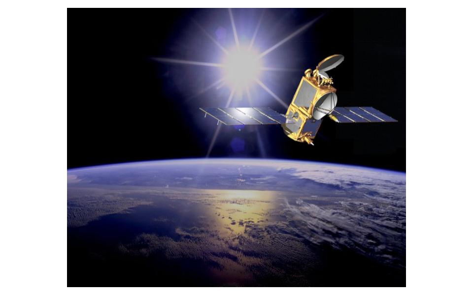
NASA has announced that the long-serving Jason-2 satellite, which has taken accurate measurements of Earth’s sea levels for the last 11 years, ended its mission on 01OCT19 and will be decommissioned on 10OCT19. The spacecraft was the third in a line of four (so far) which have continued to track worldwide sea levels in an unbroken record since the early 1990s. The mission was originally slated to last 3 years.
The aging spacecraft was moved to a lower orbit in 2017 due to the degrading of various spacecraft systems, in order to put the satellite on a slightly faster track to de-orbiting than it would have had in its original circular orbit about 1,340 km / 830 mi above the Earth. It will be lowered further during the decommissioning process with the remainder of the attitude control propellant on-board; the main fuel tanks have already been vented to prevent the satellite from becoming a source of potential space junk due to unplanned depressurization, etc.
Operated jointly by NOAA, the French space agency Centre National d’Etudes Spatiales (CNES), the European Organisation for the Exploitation of Meteorological Satellites (EUMETSAT) and NASA, the mission will continue via the Jason-3 spacecraft, which was launched in June of 2016 & is already in service.
THE NAME:
According to Wikipedia: “The lineage of the name begins with the JASO1 meeting (JASO = Journées Altimétriques Satellitaires pour l’Océanographie) in Toulouse, France, to study the problems of assimilating altimeter data in models. JASON as an acronym also stands for “Joint Altimetry Satellite Oceanography Network”. Additionally it is used to reference the mythical quest for knowledge of Jason and the Argonauts.”
THE MISSION:
Launched in 2008 on a ULA Delta II rocket from Vandenberg AFB, Ca, and with an expected mission life of 3 years, the JASON-2/Ocean Surface Topography Mission (OSTM) was the third in a line of, to this point, four satellites which have provided some of the most accurate measurements ever taken of the Earth’s oceans. Starting with the TOPEX/POSEIDON satellite in 1993, the data gathered have tracked sea level rise to a precision of tenths of millimeters per year. The mission was taken over by JASON-1, which launched on 07DEC2001 & achieved a similar life span to the soon to be decommissioned Jason-2, serving until its deactivation on 01JUL2013.
In addition to sea level measurements, the JASON-2 satellite and its kin have also provided monitoring of sea surface temperatures, wind speeds & directions, and when the aging spacecraft was moved to a lower “graveyard” orbit in 2017 due to the degradation of multiple onboard components, it was still able to provide high resolution imagery of the ocean surface, and even provide a source of gravimetric data for NASA experiments which allowed the satellite’s sea surface data to be converted into topographic maps of the sea-floor.
PRAISE:
“Not only did Jason-2 extend the precise climate record established by TOPEX/Poseidon and continued by Jason-1, it also made invaluable observations for small to medium-scale ocean studies in its second, interleaved orbit,” said CNES President Jean-Yves Le Gall. “Even when moved to the ‘graveyard’ orbit, Jason-2 continued to make unprecedented new observations of the Earth’s gravity field, with precise measurements right until the end.”
THE FUTURE:
JASON-3, launched in 2016, has already taken over JASON-2’s measurements, continuing the unbroken line of satellite observations going back to the early 1990s. Sentinel 6A will eventually become the 5th satellite in the line to continue this record-keeping. Still in the final stages of development & testing, it’s currently slated for launch in late 2020 on a SpaceX F9 from Vandenberg AFB. A second Sentinel is planned for launch in 2025.
The Things that Are Coming to a Beginning
- NASA opens competition to build human-rated lunar landers (Spaceflight Now)
Credit: NASA
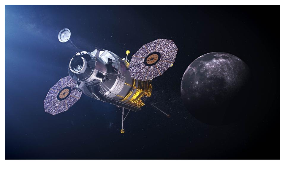
If we’re REALLY going to the Moon in 2024, we’ll want a way to get to the surface, & parachutes might not be the way to go. On September 30th, 2019, NASA released a publication calling for proposals from commercial spaceflight companies to fulfill the Human Landing System (HLS) requirements for NASA’s Artemis program. The submission deadline: 01NOV19. The reason? Initial contract awards are planned to be given out by NASA in JAN of 2020.
Said Lisa Watson-Morgan, the lander program manager at NASA’s Marshall Space Flight Center in Huntsville, Alabama, “For HLS, every action we have worked has been streamlined in order to achieve to the surface of the moon by 2024.” She later elaborated that “We have a goal of awarding the contracts in January of 2020, and all this is really needed in order for us to make the schedule of 2024.” The comments were made a Human Landing System industry day meeting on Oct. 3rd.
According to NASA, the landers for the 2024 and 2025 missions must provide the following capabilities:
- At least 1,907 pounds (865 kilograms) of payload delivered to the lunar surface, with a goal of 2,127 pounds (965 kilograms)
- At least 6.5 days on the lunar surface
- At least two spacewalks per mission, with goal of five spacewalks, using NASA-provided spacesuits
- At least 77 pounds (35 kilograms) of sample return capability, with a goal of 220 pounds (100 kilograms)
While the goal of having a totally reusable lander has not been abandoned, NASA officials have relaxed that requirement for the sake of meeting the 2024 mission goal. According to Marshall Smith, NASA’s director of human lunar exploration programs, “We actually were requiring reusability, but we got some feedback from our contractors that … it might be one thing to build an ascent element that you say you’re going to take back and forth to the moon, say five or 10 times, but it’s another thing to certify that thing to stay in space for 10 years to be reused and refueled over and over again, and it might be cheaper to build another one.”
“We’re letting that play and that trade pan out, but we will be using reusability across the board as much as we can, as long as it makes economic sense and we can look at how this affects our sustainability,” he said.
Two of the initial design study winners will be selected in OCT 2020 to fully develop & produce their designs, with the selection criteria being (in NASA’s stated order of importance) the proposed technical approach, total cost, and company management practices. NASA will then select two landers, one each for the 2024 & 2025 missions.
Nearly every major company in the American space industry has announced their intent to submit bids.
The Things that Launched
- China launches new Gaofen Earth-imaging satellite (Spaceflight Now)
- Gaofen satellite launched by Long March 4C (NASA Spaceflight.com)
TWO things have launched already this week.
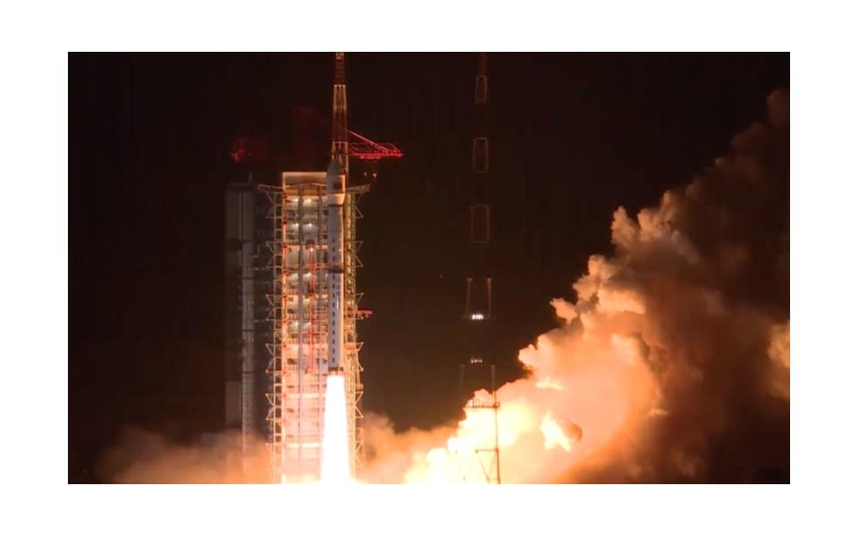
THING #1 belongs to the Chinese government. State media reported that a Long March 4 C rocket was launched on Friday, October 5th at 18:51 UTC (2:51 pm EDT / 2:51 am Sat local time) from the LC9 launch complex at the Taiyuan Satellite Launch Center in northern China’s Shanxi province. Though there’s no official word of what the payload was, the timing of the launch seems to indicate this was a replacement for a satellite which was destroyed during a launch failure back in August of 2016.
Based on previous no-fly zones & other information, we reported last week that it was likely going to be the launch of GaoFen-7, which is the only GaoFen satellite left in the constellation to be launched, and is scheduled to be launched on a Long March 4 rocket.
The mass of GF-7 is 2400 kg and it is destined for a sun-synchronous orbit (SSO). Long March 4C can take up to 2800 kg to SSO.
However, the delay of the launch until later on Friday more closely matches the planned orbit for GaoFen-10, which was destroyed during a launch failure on 31AUG2016. Chinese authorities did not confirm the previous launch failure until weeks after the event, and they are not expected to confirm this payload nor its status for some time, if at all.
US military tracking data indicates the upper stage of Friday’s launch was deployed into a circular orbit roughly 610 km / 380 mi above the Earth.
The GaoFen-10 satellite is part of the China High-Resolution Earth Observation System (CHEOS), and is capable of providing visual- & radar-imaging of the Earth to below 1 m / 3.3 ft resolution. China has previously released some of that constellation’s images to the general public, and say the data are used for urban planning & land use, crop yield assessment & disaster mitigation. The name “GaoFen” literally translates to “high resolution” in English.
The CHEOS system, of which the GaoFen constellation is a part, is operated by the Earth Observation System and Data Center (EOSDC) of the China National Space Administration (CNSA). The EOSDC was established in March of 2010, and is responsible for the construction & operation of CHEOS, which is intended to provide a near-real-time, all-weather, global surveillance network consisting of satellites, stratosphere airships, and other various aerial observation platforms.
Chinese officials have said that the CHEOS system is “civilian operated,” however all of the previously mentioned organizations are direct spin-offs of the state-run governmental space agency. “Civilian” means something slightly different in Chinese parlance than in most of the rest of the world: here it just means that it isn’t run by active-duty military personnel; the agency itself is still “government-operated” by most standards. In this respect it compares fairly well to agencies like Roscosmos or NASA, versus ILS or SpaceX (e.g.).
THING #2 is an International Launch Services Proton rocket with a Briz-M upper stage.
- Eutelsat 5 West B & MEV-1 Info Sheet (Mission Overview)
- Proton-M launch scheduled for October 9 (TASS.ru)
- MEV Mission Profile (YouTube)
- EUTELSAT 5 West B Ku-Band Commercial Communications Satellite (Northrop-Grumman)
- Mission Extension Vehicle (MEV) (Northrop-Grumman)
- Launch Schedule (Spaceflight Now)
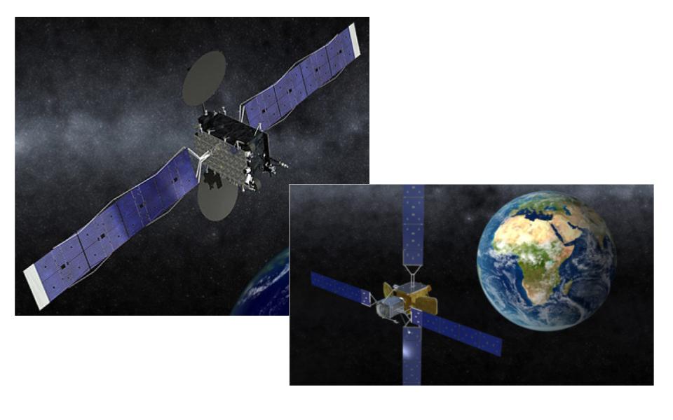
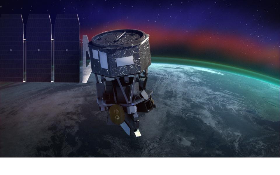
RIGHT IMAGE: Artist’s rendering of Mission Extension Vehicle (MEV-1): Orbital ATK / Northrop Grumman
On October 9th at 10:17 UTC, ILS launche two Northrop-Grumman-made satellites: Eutelsat 5 West B & MEV-1. Launch was conducted from pad 39 at the Baikonur Cosmodrome in Kazakhstan, rather than Plesetsk in Russia as originally reported.
This mission was supposed to launch on September 30th from Plesetsk Cosmodrome. Reason for launch change was official reported as “a problem related to the interface between the Russian control system and the spacecraft electronics.”
Some milestones for today’s launch:
- • 1st ILS Proton Launch in 2019
- 2nd ILS Dual Launch / 1st Dual Launch with 2 Commercial Satellites
- 97th ILS Proton Launch Overall
- 8th Eutelsat Satellite Launched on ILS Proton
- 6th and 7th NGIS Satellites Launched on ILS Proton
- 1st SpaceLogistics LLC Satellite Launch (a subsidiary of Orbital ATK, a division of Northrop-Grumman)
Massing about 2,900 kg / 6,300 lbs, Eutelsat-5 West B (E-5WB) is a high capacity Ku-band communications satellite which will be serve customers primarily in Europe & North Africa. Initially, E-5WB will share an orbital slot with E-5W (hence the “B” in the name) & both satellites will work together to provide service to customers. Eventually the new satellite will take over operations when the older E-5W is decommissioned. It is expected to have a life-span of ~15 years.
The Mission Extension Vehicle-1 (MEV-1) massing just over 2,300 kg / 5,100 lbs, is intended to test the concept of on-orbit mission extension of existing satellites by attempting to rendezvous with Intelsat’s IS-901 communications satellite. Once there, the craft will physically join with IS-901 & provide station-keeping + attitude control services, allowing the out-of-fuel satellite to continue its commercial mission for another 5 years. IS-901 passed its expected end of life (EEOL) back in AUG 2014.
If successful, MEV-1 will extend IS-901’s mission by about 5 years before lifting it into a graveyard orbit, undocking, and moving on to potentially provide the same service to two OTHER satellites in geosynchronous orbit over an additional 10 yr period. (IOW, MEV-1 is theoretically capable of performing the IS-901 mission 3 separate times for three different GEO satellites!)
The Things that are Launching
- Ionospheric Connection Explorer – ICON blog (NASA)
- ICON Mission (RocketLaunch.Live)
- Launch Schedule (SpaceLaunch.Live)
- Stargazer (aircraft) (Wikipedia)
- ICON – Spacecraft and Instruments (NASA)
Next — the things that are launching this week! There are two future launches to discuss, one later today, one coming within a week.
Later on this evening, if you’re in the Western Hemisphere:
On October 10 @ 01:30 UTC (or, October 9th @ 9:30 pm Eastern Time), Northrop Grumman is launching ICON on a Pegasus rocket from a Stargazer L-1011 which in turn will take off from Cape Canaveral AFS in Florida, United States.
Now, let’s take a second and break that down. We’re used to missions being launched on rockets. That’s not a problem. What we’re NOT used to is rockets being launched from airplanes. So, what does that even look like?
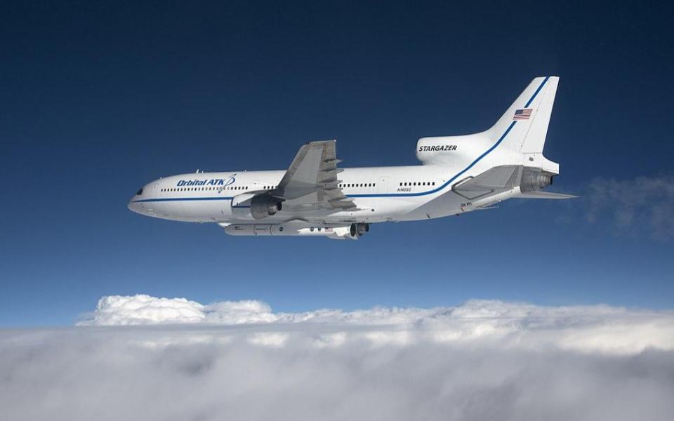
Photo credit: NASA/Lori Losey
….It looks like a huge commercial airliner with a rocket strapped to the bottom. Specifically, the Stargazer is a Lockheed L-ten-eleven TriJet and is only one of three that are still considered flight-worthy. During its time in service as a mother ship, Stargazer has launched at least 43 rockets.
The ICON spacecraft itself will orbit the Earth at an altitude of ~580 km / 360 mi at an inclination of 27 degrees. This will allow the satellite to get views of the Earth’s atmosphere over the equator from several angles, allowing data to be gathered from the Karman Line all the way to orbital altitude.
A list of ICON’s instruments follows:
- MIGHTI: The Michelson Interferometer for Global High-resolution Thermospheric Imaging instrument observes the temperature and speed of the neutral atmosphere. These winds and temperature fluctuations are driven by weather patterns closer to Earth’s surface. In turn, the neutral winds drive the motions of the charged particles in space. MIGHTI is built by the Naval Research Laboratory in Washington, DC.
- IVM: The Ion Velocity Meter will observe the speed of the charged particle motions, in response to the push of the high altitude winds and the electric fields they generate. The IVM is built by the University of Texas at Dallas.
- EUV: The Extreme Ultra-Violet instrument captures images of oxygen glowing in the upper atmosphere, in order to measure the height and density of the daytime ionosphere. This helps track the response of the space environment to weather in the lower atmosphere. EUV is built by the University of California at Berkeley.
- FUV: The Far Ultra-Violet instrument captures images of the upper atmosphere in the far ultraviolet light range. At night, FUV measures the density of the ionosphere, tracking how it responds to weather in the lower atmosphere. During the day, FUV measures changes in the chemistry of the upper atmosphere — the source for the charged gases found higher up in space. FUV is built by the University of California at Berkeley.
Now, let’s talk about the payload. Ionospheric Connection Explorer, or ICON, will study the ionized part of Earth’s upper atmosphere. This is the region where Earth weather meets space weather.
You know how Dr Pamela says that space telescopes are dead to her until they get first light? ICON is an example of why. The first launch date was in June 2017. Repeated delays have kept pushing back launch. Hopefully, it will launch this evening — well over two years from the original launch date, and over the Atlantic instead of the Pacific, but still! Hope!
Once ICON is in orbit, it will collect data of plasma and airglow to further our understanding of the density, composition and structure of the ionosphere. As NASA puts it, “The Ionospheric Connection Explorer will study the frontier of space: the dynamic zone high in our atmosphere where terrestrial weather from below meets space weather above. In this region, the tenuous gases are anything but quiet, as a mix of neutral and charged particles travel through in giant winds… Variations there can result in distortions or even complete disruption of signals. In order to understand this complicated region of near-Earth space, called the ionosphere, NASA has developed the ICON mission. To understand what drives variability in the ionosphere requires a careful look at a complicated system that is driven by both terrestrial and space weather.
“ICON will help determine the physics of our space environment and pave the way for mitigating its effects on our technology, communications systems and society.” https://www.nasa.gov/content/icon-mission-overview
The launch will be covered live on NASA TV. beginning at 9:15 pm EDT / 01:15 UTC https://www.youtube.com/watch?v=21X5lGlDOfg
And finally, one last launch for the upcoming week:
- As the Crow Flies (RocketLabUSA)
- Momentus reports success in testing water plasma propulsion (Space News)
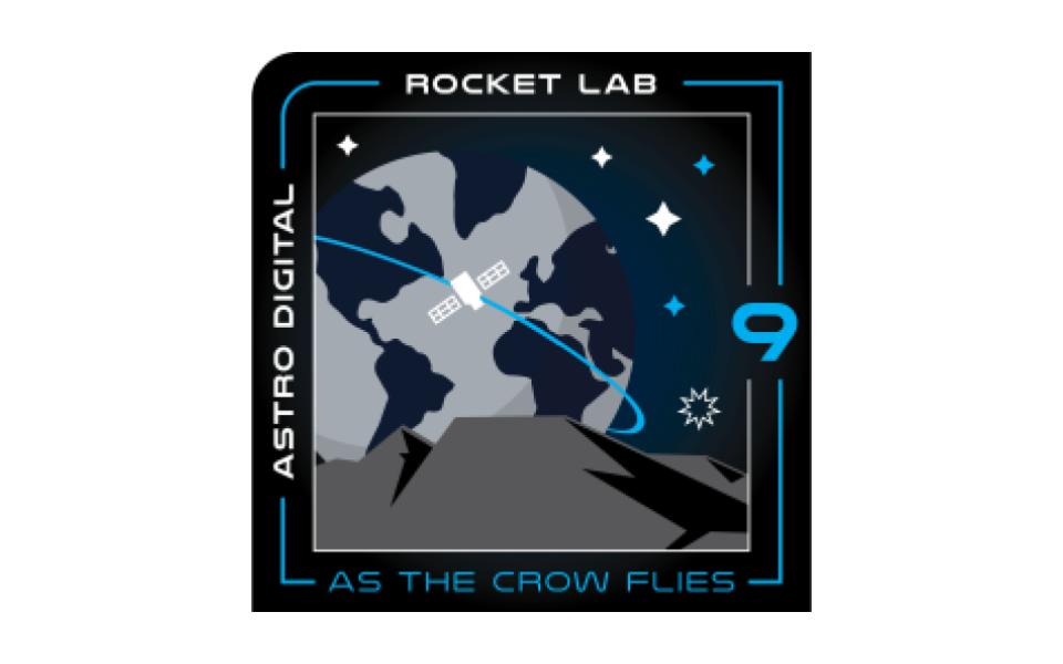
“AS THE CROW FLIES”
Launch Window: Monday 14OCT19 23:00 UTC – 03:00 UTC Tuesday 15OCT19Overall window: 14OCT19 – 28OCT19, same times. Launch Site: L.C. 1, Mahia Peninsula, New Zealand
Mission: Launch a 16U CubeSat technology demonstration platform for Astro Digital into LEO.
Astro Digital is a satellite manufacturer and operator based out of Santa Clara, California which produces the “Corvus” line of satellite platforms. These range from 6U & 16U CubeSat class to ESCP class, and are most often used for technology demonstration, satellite communications &/or Earth observing missions. The Rocket Labs mission name is a nod to the AD product line via a reference to the crow, an intelligent, widely distributed bird which is a member of the genus Corvus. It will be the ninth flight of an Electron rocket from the Mahia launch site.
This particular mission will place a 16U-sized CubeSat bus into a near-circular LEO, which will subsequently test an onboard propulsion system of Astro Digital’s design, as well as a new AD-designed communications system. Rounding out the payload, a software package developed by Advanced Solutions Inc. will also fly which includes ASI’s MAX Flight simulator. Very few details are available regarding the precise nature of the technologies to be demonstrated & the mission steps or criteria which will be performed. This is likely due to the proprietary nature of the systems involved.
That said, a recent mission called El Camino Real may shed some light on at least one of the “As the Crow Flies” payloads:
In general, the point of a CubeSat-/small-sat class satellite is to lower the cost to a customer that wants to perform a space-based service set. This is done by lowering construction costs by making a much smaller bus than normal to carry the desired payload (smaller generally means cheaper), and the smaller size then allows many such satellites to ride on a single launch platform.
However, the same economic constraints which cause a company to consider Cubesat-class satellites means they must ride along with other, larger missions… which means the small-sat operator must either settle for being “dropped off” on the way to the primary customer’s orbit, or else wait for one that happens to be going the same place. Given the already reduced satellite size, this set of factors means that the small-sat thus launched often cannot get where the customer might want it to go. This can drastically limit access to certain regions of near-Earth space, and the delays & costs associated with being a secondary cargo can financially doom a small-sat mission.

The El Camino Real demonstrator, built by Astro Digital & using fellow California-based company Momentus’ new propulsion system, was one of 33 small sats launched on July 5th 2019 aboard a Soyuz 2.1b rocket w/a Fregat upper stage. Its purpose was to test a new propulsion technology involving the superheating of water using microwaves, thus turning it into plasma, and using that plasma for propulsion. It’s hoped this will be a cheaper, safer alternative capable of maneuvering a CubeSat-class satellite much further away from its drop-off point as part of a larger mission. This in turn should help to open up a much wider range of useful orbits & mission profiles for the CubeSat market.
As of 25SEP19, the El Camino Real satellite was still on-orbit & conducting periodic firings of its water plasma propulsion system.
———————
And that rounds out our show for today.
Thank you all for listening. The Daily Space is produced by Susie Murph, and is a product of the Planetary Science Institute, a 501(c)3 non profit dedicated to exploring our Solar System and beyond. We are made possible through the generous contributions of people like you. If you would like to learn more, please check us out on patreon.com/cosmoquestx
Each live episode of the Daily Space is archived on YouTube. If you miss an episode here on Twitch.tv, you can find it later on youtube.com/c/cosmoquest. These episodes are edited and produced by Susie Murph.
We are here thanks to the generous contributions of people like you who allow us to pay our staff a living wage. Every bit, every sub, and every dollar committed on Patreon.com/cosmoquestx really helps. If you can’t give financially, we really do understand, and there are other ways you can help our programs. Right now, the best way you can help is to get the word out. Let you friends know, share our channel to your social media, or leave a recommendation. You never know what doors you are opening.
We really wouldn’t be here without you – thank you for all that you do.
 We record most shows live, on Twitch. Follow us today to get alerts when we go live.