
We live on a geologically active rocky world that is uniquely shaped by a combination of water-driven weather and complex life. Currently, we are the only world we know of capable of supporting humans without requiring advanced technologies and mitigation against radiation and the certain death of environmental toxins.
Understanding our world is a basic need if we want to preserve and protect life, but in many ways, the politics of humans makes studying our world weirdly difficult.
Earlier this week, I got a notification from NASA that one of their funding programs had to be canceled because of DOGE’s cuts to USAID. In order to help support humanitarian efforts, NASA has provided researchers who use satellite data to study our planet. No US aid means no humanitarian efforts, which means no Earth science research in those parts of the world. While I am fundamentally more upset about the cuts to HIV drug disbursement programs and the elimination of nutritional support for starving children, I am also annoyed that research that could have a long-term impact on the well-being of large populations is just not going to happen.
So far, NASA hasn’t experienced the same society-harming cuts we’ve seen other agencies experience, but, these are the cuts relevant to our show and my career, so they are going to get mentioned.
And now we’re going to move along and talk about wild flowers.
Seriously.
The changing colors of the seasons seen as chemistry
While a lot of Earth science involves individual researchers and teams of researchers going out into the field to directly study our planet’s earth, air, water, and life, this isn’t the most effective way to study things that happen over large areas of large periods of time.
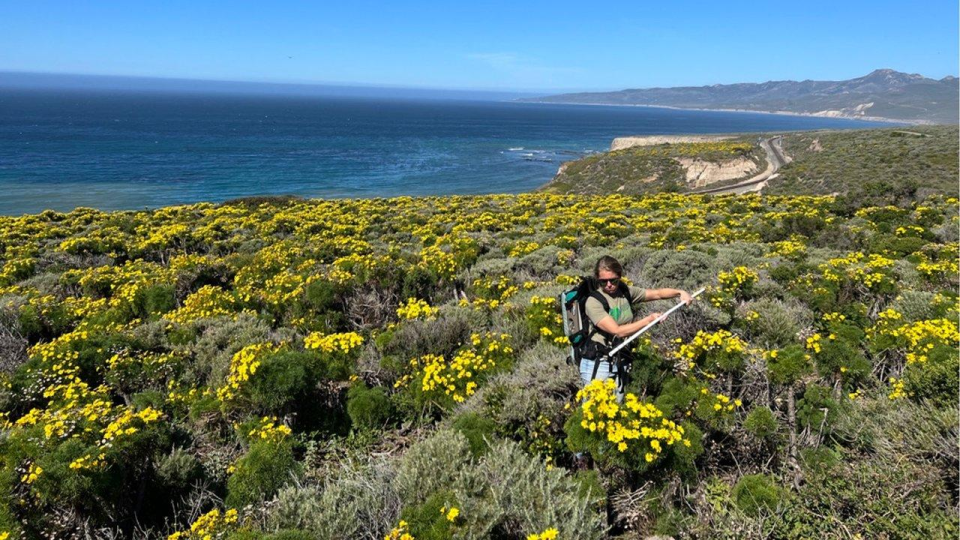
Consider, for instance, the importance of flowers, bugs, and other pollinating critters all coming onto the scene at the same time. The emergence of animals and plants each spring is linked to the changing amount of life we get with the changing seasons and also to changing temperatures. While our orbit is keeping sunrise and sunset on a millennia-old schedule for now, climate change is causing temperatures to rise earlier than we’ve seen historically, and this is causing things like flowers to emerge earlier than ever before. We’re also seeing changing weather patterns that are bringing water to the deserts and triggering rare mega blooms of flowers.
The initial emergence of blooms is often noted by volunteers reporting what they see while out on a hike using either citizen science apps or social media. Monitoring these reports are researchers like NASA-funded Yoseline Angel, a scientist at the University of Maryland and Goddard Space Flight Center. She is using data from a camera on the ISS that looks at the chemistry of light reflecting off Earth. Flower pigments come from 3 chemical families, each absorb light in unique ways that we can see from space. This means it’s possible to see in the combined light of vast swaths of Earth the distinct signature of flowers. The more flowers stand in the Sun, the stronger the signature will show up in the camera’s data.
On the other side of the US, NASA-funded researchers at the Jet Propulsion Laboratory have developed an airplane-mounted camera that does similar work but can capture more details from its closer-to-Earth perspective. This airplane-based instrument was, according to NASA, “able to capture 97% of the subtle spectral differences among flowers, leaves, and background cover (soil and shadows) and identify different flowering stages with 80% certainty.” This data will aid in everything from farming to land management to predicting changing fire risks.
The ocean floor studied from outer space
The emptiness of our world is perhaps one of its least appreciated features. While there are some areas that have populations in numbers I struggle to comprehend, with megacities that have populations greater than the entire American Midwest, the world is, by and large, unpopulated, and this makes satellite usage all the more important for tracking our worlds ever changing features. And this is equally true for studies of shifting icebergs and shifting sea mounts.
It turns out that it is possible to map the floor of the ocean using satellites, not with images or with radar, but rather with gravity. The SWOT satellite was designed to map out the surface height of water for use in tasks like measuring how flooding propagates along rivers. It turns out, however, that the average height of water on the ocean corresponds to the pull of gravity beneath the ocean. Rocks, minerals, and other features are denser than water and can compress the water. SWOT is sensitive enough to detect these variations. A collaboration between NASA and the French space agency with contributions from Canada and the UK, SWOT released it’s first map of the ocean floor in December and is now working to refine that initial map. While gravity measurements don’t give us the same details we get from boat mounted sonar, the data is good enough to aid in finding the best places to lay cables, and to help us study currents, the geology of how the world’s crusts have separated over time, and more.
There had once been a goal to map the world’s sea floor with high-resolution sonar by 2030, and that task is one we are now admitting won’t be completed, but these maps help us set priorities and fill in our gaps with low-resolution data that is better than no data at all.
Monitoring emissions from outer space
Dataset by dataset, we’re realizing that we want more ground-based data, but we don’t have the resources so space-based data it is.
A new study from the Chinese Academy of Sciences combines satellite data from NASA’s Orbiting Carbon Observatory (OCO) satellites and EPA’s Clean Air Markets Program Data to look at emissions from 1,060 U.S. power plants. They determined that satellite data alone underestimated emissions by as much as 70%, with only 72 large plants accurately getting measured. Through modeling they could improve things somewhat, but ultimately, in order to track who is and isn’t following clean air regulations and working toward the agreed upon Paris Climate Accords, we’re going to need to have more sensitive spacecraft that both have higher spatial resolution and greater sensitivity in terms of part per million that can be measured.
One of the the things that caught my attention about this research is this was Chinese funded researcher, focused on climate change, using US federally funded data to study emissions in the US… and this is research that US researchers likely can’t do use US funding after recent cuts and the release of restricted vocabulary that prohibits the discussion of climate change in many different contexts.
We live in unusual times. Our world is changing in response to human-made pollutants, redistribution of flora and fauna, and things like turning the planet – or at least large swath of America – into a parking lot. Defunding research into these changes won’t make them go away, but it will make it harder for us to prepare effectively for the rising water levels, increasing weather and fire hazards, and other issues that will just make it harder for us to subsist on our planet.
At least we know now the Chinese Academy of Science is funding and doing some of this research for us.